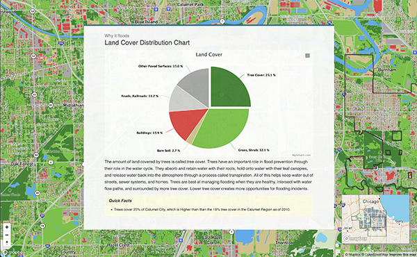
The Calumet Region, like much of Cook County, experiences flooding because of multiple factors. Explore this tool to see data about where it floods, why it floods, and who is most impacted by flooding.
The Urban Flooding Baseline Tool seeks to inform community residents, and municipal and regional leaders that flooding is experienced across communities, not just within individual homes. The tool provides content knowledge to assist with community advocacy, municipal action, and regional stormwater planning efforts. Flooding is a reality, but communities can take steps to reduce the impact.
The goals of the project are to:
- Clearly define the problem of urban flooding in the Calumet region to help regional stormwater planning efforts.
- Construct an urban flooding risk dashboard for municipal and community leaders to guide municipal actions and support community advocacy.
- Create a data collection process in which community members collect photos of where flooding occurs to support local fundraising efforts for solutions.
What is Urban Flooding?
Urban flooding occurs when rain overwhelms drainage systems and waterways in built-up and more densely populated environment, and makes its way into the basements, yards, and streets of homes, businesses, and other structures, disrupting lives and economic activity.
The map will include publicly available data to identify flooding risk, as well as information from a resident-run data collection process. CNT, with help from SSMMA, will roll out a data collection process with an advisory group consisting of community members interested in urban flooding issues. The data collection process (from March 2021- May 2022) will employ community members to take geographically tagged photos of externally flooded areas within certain South Suburban Communities, (Dixmoor, Dolton, Harvey, Phoenix, Posen, Riverdale, and parts of unincorporated Thornton Township). These photos will be submitted to an online app titled CNT Flood Photo App with additional information about the time of flooding, estimated depth, and description of how it impacts residents.
If you have any questions about this project, please reach out to Cyatharine Alias (calias@cnt.org) for more information.


 Strengthening Transit Through Community Partnerships